Go to top

1834 CE Fellahin Revolt Quake

6 am 26 May 1834 CE

by Jefferson Williams


Damage Distribution from 1834 and 1837 CE Quakes
   Fig. 3 - Damage distribution and its severity, ranging between ‘Moderate’
    and ‘Severe’ of the May 1834 and January 1837 earthquakes, according to
   historical reports. - from Zohar et al (2015)


Introduction & Summary

1834 CE Fellahin Revolt Earthquake Summary

Textual Evidence

Text (with hotlink) Original Language Religion Date of Composition Location Composed Notes
Damage Reports from Textual Sources n/a n/a n/a n/a n/a
Letter from an anonymous Welsh traveler to Jerusalem English translated from Welsh Christian 16 July 1834 CE Jerusalem An eyewitness described an earthquake in Jerusalem while it was being captured and sacked by rebel forces during the 1834 CE Fellahin Revolt which dates the earthquake to late May or early June of 1834 CE. The earthquake was said to have destroyed many houses, and levelled to the earth that part of the city wall which passes the temple of the Muhammadans. The monastery of Bethlehem was rendered uninhabitable and many of the inhabitants were killed in the ruin of their houses. For ten days earthquakes continued to rock the city, though none of them was by any means so severe as the first.
Report by the Monk Neophytos English translated from Greek Greek Orthodox Neophytos dated the earthquake in the Julian Calendar. Once this date is converted to the Gregorian calendar, his time and date for the earthquake is 6 am Sunday 26 May 1834 CE. Neophytos described the earthquake as lasting but three seconds yet so violent that the dome of the Catholicon was cracked in seven places and all the plaster fell off. He also noted that the big dome of the Church of the Holy Sepulchre was shaken, but being of wood and well bound together, it was not greatly damaged. Many big houses in Jerusalem were cracked and many fell. Part of the city wall, near the Mosque of Omar, fell. A minaret fell in Jerusalem, and another one on the Mount of Olives, as did the dome of the Shrine of the Ascension. In Bethlehem the monasteries of the Franks and the Armenians and ours were greatly damaged, especially the belfry. By God's mercy the beautiful Church of the Nativity of our Lord Jesus Christ, as well as the new pilgrim-house, was not damaged.
Baptisin Poujoulat French ~1837 CE Baptisin Poujoulat reported that Jerusalem experienced a violent earthquake in 1834 CE which also tore down the walls of Caesarea. In possible hyperbole, he reports that 4000 people died under the rubble in Caesarea and that the earthquake was preceded by thick smoke, distant rumblings, and multicolored flames coming out of Mount Argée (location unknown). Poujoulat reports that in Caesarea minarets, vaults, mosques, churches, and carvanaseris partially collapsed and several (nearby?) villages were partially destroyed. A salt water lake is said to have inundated a village known as Komtzi.
Edward Robinson English 1838 CE Edward Robinson reported second hand accounts that a large quantity of asphaltum was cast upon the shore near the SW part of the Dead Sea after the earthquake of 1834 CE.
Titus Tobler German 1853 CE Titus Tobler wrote that in July 1834 CE, an earthquake threw down several structures in Jerusalem, damaged part of a wall near a Mosque in the same city, and threatened the collapse of the Latin Rlofters (?)
William McClure Thomson English Protestant Christian around April 1857 CE Jaffa In a passage written around April 1857 CE, William McClure Thomson recalled his experiences during the 1834 CE Fellahin Revolt Earthquake. He was in Ramleh at the time of the earthquake. In Ramleh, the earthquake cracked nearly all the houses and threw down many. A tower in Jaffa had been rudely shaken by the same earthquake. He dated the earthquake to 23 years before he was writing (i.e., 1834 CE) and while rebel forces occupied Jerusalem (late May/ early June 1834 CE).
History of the Greek Orthodox Patriarchate of Jerusalem English Christian 1913 CE A History of the Greek Patriarchate of Jerusalem states that the Dome of the Catholicon was partly destroyed in an earthquake in 1834 CE. The Catholicon apparently refers to the Church of the Holy Sepulchre.
Menahem Mendel of Kamieniec Jewish Zohar et al (2015:244 n. 2) report that Menahem Mendel of Kamieniec (1800-73) dates the event to the 30th count of the Jewish ‘Omer’ which, according to Zohar et al (2015:244 n. 2), corresponds to 14 Iyyar. If one assumes a Hebrew year of 5594, this converts to a Gregorian date of Friday, 23rd of May (Mendel 1839). Zohar et al (2015:244 n. 2) also report that Mendel wrote that there were two shocks - one at noon and the second at night (Mendel 1839).
Other Authors
Text (with hotlink) Original Language Religion Date of Composition Location Composed Notes
Damage Reports from Textual Sources

Seismic Effects

´

Partial List of Seismic Effects
Effect Sources Notes
Destroyed or damaged houses in Jerusalem Anonymous Welsh Traveler, Neophytos
Wall outside Al-Aqsa Mosque Damaged Anonymous Welsh Traveler probable location
Wall outside Mosque of Omar fell Neophytos
Wall outside an unnamed Mosque (presumably in Jerusalem) partly damaged Titus Tobler
threatened the collapse of the Latin Rlofters (?) in Jerusalem Titus Tobler
A minaret fell in Jerusalem Neophytos
A minaret on the Mount of Olives fell Neophytos
The dome of the Shrine of the Ascension fell Neophytos
Monastery in Bethlehem Damaged Anonymous Welsh Traveler, Neophytos Neophytos was more specific - In Bethlehem the monasteries of the Franks and the Armenians and ours were greatly damaged, especially the belfry but the beautiful Church of the Nativity of our Lord Jesus Christ, as well as the new pilgrim-house, was not damaged
Dome of the Catholicon (Jerusalem) cracked Neophytos, History of the Greek Orthodox Patriarchate of Jerusalem
City Walls of Caesarea damaged Baptisin Poujoulat
The minarets, the vaults, mosques, churches, and carvanaseris partly collapsed in Caesarea Baptisin Poujoulat
sea water inundated a village called Komtzi Baptisin Poujoulat
Tower in Jaffa rudely shaken William McClure Thomson
cracked nearly all the houses in Ramleh, and threw down many William McClure Thomson
A large quantity of Asphalt appeared on the SW shore of the Dead Sea Edward Robinson

Locations

Locations
Location Sources Notes
Jerusalem Anonymous Welsh traveler, Neophytos, Baptisin Poujoulat, Titus Tobler, History of the Greek Orthodox Patriarchate of Jerusalem
Bethlehem Anonymous Welsh traveler, Neophytos
Caesarea Baptisin Poujoulat. William McClure Thomson1
Ramla William McClure Thomson
Jaffa William McClure Thomson unclear if there was significant damage
Dead Sea Edward Robinson, Blankenhorn (1905:208)
Dhiban Tristram et al (1873) speculative - see Archeoseismic Evidence
an area 10 leagues (~55 km.) south of Mount Argée (?) Baptisin Poujoulat
a village called Komtzi Baptisin Poujoulat
Footnotes

1 Thomson (1861:502) wrote something in 1857 CE that may or may not recall earlier seismic damage to the walls of Caesarea during the 1834 CE Fellahin Revolt Earthquake

I recalled the day and night I spent among Caesarea's broken walls and prostrate columns more than twenty years ago. Fresh from scenes of war, and earthquake, and sickness, and death in Jerusalem, I then felt a mysterious sympathy with these sad and forsaken ruins.

Letter from an anonymous Welsh traveler to Jerusalem

Report by the Monk Neophytos

Voyage dans l’Asie-Mineure en 1836–7 by Baptisin Poujoulat

Biblical Researches in Palestine, Mount Sinai and Arabia Petraea, A Journal of Travels in the Year 1838 by Edward Robinson

Denkblatter aus Jerusalem by Titus Tobler

The Land and the Book by William McClure Thomson

History of the Greek Orthodox Patriarchate of Jerusalem

Menahem Mendel of Kamieniec

Other Authors

Archaeoseismic Evidence

Location (with hotlink) Status Intensity Notes
Jerusalem - Introduction n/a n/a n/a
Jerusalem - Mount Zion possible to probable ≥8 Zohar et al (2015) compared drawings from 1833 CE and earlier to drawings and photographs from 1838 CE and later to conclude that the Ottoman minaret known as al-Nabi Da'ud on top of King David’s Sepulchre at Mount Zion was rebuilt to a shorter size likely due to damage incurred in the 1834 CE Fellahin Revolt Quake. The contemporaneous eye-witness source Neophytos wrote that a minaret fell in Jerusalem. Minarets are frequently damaged during earthquakes due to their vulnerability to seismic shaking.
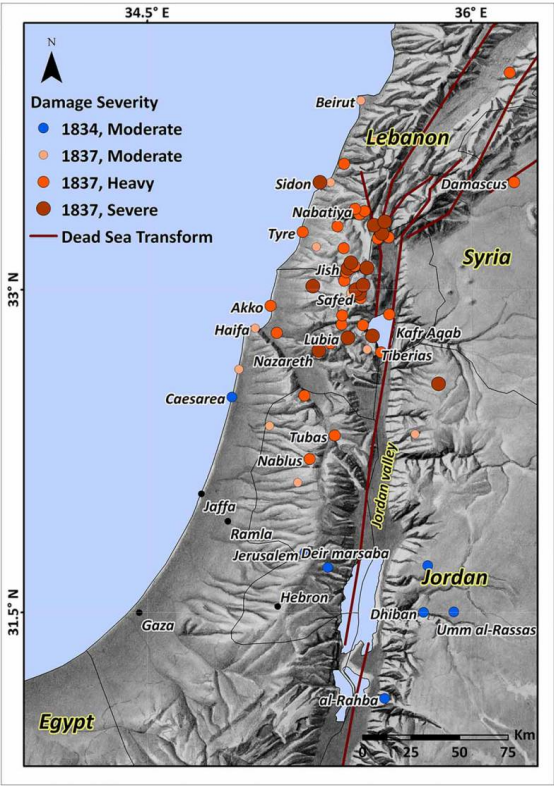
Dhiban possible Tristram et al. (1873:135), while speculating on the discovery of the Mesha Stele in 1868 CE, suggested that the Stele was first exposed during the Safed earthquake of 1 January 1837 CE probably unaware that if an earthquake from around that time exposed the Mesha Stele, it would probably have been the 1834 CE Fellahin Revolt Earthquake.
Location (with hotlink) Status Intensity Notes
Jerusalem - Introduction


Jerusalem - Mount Zion


Dhiban


Tsunamogenic Evidence

Paleoseismic Evidence

Location (with hotlink) Status Intensity Notes
Taninim Creek Dam possible
Flame structures - ~1500-~1900 CE

Marco et al (2014) observed zigzaged flame structures atop a permeable lacustrine unit wedged between two impermeable units. They interpreted the flame structures to be a result of overpressures or liquefaction. They surmised that the liquefaction was either induced directly by seismic shaking or by loading from a tsunami that breached the dam and placed a load of ~3 m of (additional ?) sloshing water above the sediment-water interface. Stone displacements observed on the northern part of the dam along with the spatial distribution and the zigzaged nature of the flame structures (indicating shearing) led them to favor the tsunamogenic interpretation. If correct, a tsunamogenic interpretation suggests an offshore slope failure during the causitive earthquake as active faults are not known to be present in this part of the coast.

The flame structures would have formed below the sediment water interface making this event difficult to date. Dating was approximate and was based on stratigraphy, archaeology, and textual accounts. The permeable lacustrine unit was assumed to have been deposited within an artificial lake that formed behind a dam that was originally constructed around 400 CE. Based on an estimated deposition rate, Marco et al (2014) surmised that it was deposited between ~400 CE and ~1400-1700 CE. Only one organic sample taken about 0.3 m above the flame structures produced a radiocarbon date. It dated to 250 yrs BP. Error bars were not presented but can be assumed to be between ±20 and ±75 years. Marco et al (2014:1451-1453) argued that a fresh brackish water lake behind the dam was present in some form during the late Ottoman period, possibly until the 18th century CE, due to the presence of flour mills on the west side of the dam which would have been powered by water from the dam. However, this may be contradicted by the presence of a pedogenic soil which formed above the permeable lacustrine unit presumably after the lake dried out. The pedogenic soil, however, contained freshwater fossils suggesting that the lake may have dried out, formed a soil horizon, and then filled intermittently again.

It also has to be noted that some dates discussed in their paper (e.g. dating the the sharp lithological boundary between the permeable lacustrine unit and the overlying clayey unit to circa 18th century) disagree with the Century track in the stratigraphic column they presented in Figure 3.

Historical evidence was based on Ambraseys and Barzanagi (1989) who, according to Marco et al (2014:1457), described "boats that were swept ashore from the Akko harbor (50 km north of the studied site), and a large wave that was reported from as far south as the Nile Delta", presumably due to the 25 Nov. 1759 CE Baalbek Quake. Although Marco et al (2014) suggested that the 25 Nov. 1759 CE Baalbek Quake was the most likely candidate for the flame structures, the date is, unfortunately, not well constrained.

Dead Sea - Seismite Types n/a n/a n/a
Dead Sea - ICDP Core 5017-1 possible to probable 6 Lu et al (2020a) associated a 3 cm. thick turbidite in the core to the 1834 CE Fellahin Revolt Earthquake. CalBP is reported as 153 ± 44 yr B.P. This works out to a mean date of 1797 CE with a 1σ bound of 1753 - 1841 CE.
Dead Sea - En Gedi possible see table
Potential Seismites in En Gedi

Migowski et. al. (2004) identified several seismites from around this time.

Depth (cm.) Thickness (cm.) Seismite Type Min. Intensity Max. Intensity Quake Assignment (Migowski) Quake Assignment (Williams)
-13 10 4 8.2 9.0 1927 CE not assigned
3 3 4 8.0 8.8 1837 CE 1834 CE
8 3 4 8.0 8.8 1822 CE not assigned - 1822 CE Quake unlikely - too far away
22 2 4 8.0 8.8 1759 CE not assigned
27 12 4 8.2 9.0 1712 CE not assigned
41 4.8 4 8.1 8.9 1656 CE not assigned
52 1 1 5.6 7.0 1588 CE not assigned

Dead Sea - Nahal Ze 'elim possible n/a
Potential Seismites at site ZA-1

At site ZA-1, Ken-Tor et al (2001a) identified two seismites from around this time. Event H was higher up in the section.

Event Thickness (cm.) Seismite Type Modeled Age (± 2σ) Intensities Quake Assignment (Ken-Tor) Quake Assignment (Williams)
G 50 Liquefied Sand 1815 CE ± 145 unavailable for now - different mechanism 1834 CE Quake not assigned
H 30 Liquefied Sand 1595 CE ± 75 unavailable for now - different mechanism 1927 CE Quake not assigned

Araba - Introduction n/a n/a n/a
Araba - Qasr Tilah possible ≥ 7 Haynes et al. (2006) dated Event I to between 1515 and 1918 CE and suggested it was most likely a result of the 1546 CE earthquake.
Araba - Taybeh Trench possible ≥ 7 LeFevre et al. (2018) dated Event E1 to 1744 CE ± 56.
Araba - Trenches in Aqaba possible ≥ 7 Niemi (2011:153) noted that the most recent scarp-forming event fault [in Trench AQ-1] occurred after A.D. 1045-1278 based on a corrected, calibrated radiocarbon age from charcoal collected from a buried campfire at the base of the scarp in Trench T-1. This likely represents fault motion in one of the historical earthquakes affecting southern Jordan (e.g. 1068, 1212, 1458, or 1588).
Location (with hotlink) Status Intensity Notes
Taninim Creek Dam


Dead Sea - Seismite Types


Dead Sea - ICDP Core 5017-1

Lu et al (2020a) associated a 3 cm. thick turbidite in the core to the 1834 CE Fellahin Revolt Earthquake. CalBP is reported as 153 ± 44 yr B.P. This works out to a mean date of 1797 CE with a 1σ bound of 1753 - 1841 CE. Ages come from Kitagawa et al (2017). The deposit is described as a 3 cm. thick turbidite (MMD). Lu et al (2020) estimated local seismic intensity of VI which they converted to Peak Horizontal Ground Acceleration (PGA) of 0.09 g. Dr. Yin Lu relates that "this estimate was based on previous studies of turbidites around the world (thickness vs. MMI)" ( Moernaut et al, 2014). The turbidite was identified in the depocenter composite core 5017-1 (Holes A-H).

See the following from Lu et al (2020b) regarding estimating intensity from turbidites:

Previous studies have revealed that the intensity threshold for triggering historic turbidites are variable in different regions and range from MMI V½ to VII½ (Howarth et al., 2014; Moernaut, 2020; Van Daele et al., 2015; Wilhelm et al., 2016). The intensity threshold constrained from the Dead Sea data (≥VI½) is situated in the middle of this range.

Previous studies in Chilean lakes have indicated that the (cumulative) thickness of historic turbidites across multiple cores correlates with seismic intensity, and can thus be used to infer paleo-intensities in this setting (Moernaut et al., 2014). However, in the case of the Dead Sea core 5017-1, there is a random relationship (a correlation factor of 0.04) between the thickness of prehistoric turbidites and seismic intensity (Figure 5a).


Dead Sea - En Gedi

Migowski et. al. (2004) identified several seismites from around this time.

Depth (cm.) Thickness (cm.) Seismite Type Min. Intensity Max. Intensity Quake Assignment (Migowski) Quake Assignment (Williams)
-13 10 4 8.2 9.0 1927 CE not assigned
3 3 4 8.0 8.8 1837 CE 1834 CE
8 3 4 8.0 8.8 1822 CE not assigned - 1822 CE Quake unlikely - too far away
22 2 4 8.0 8.8 1759 CE not assigned
27 12 4 8.2 9.0 1712 CE not assigned
41 4.8 4 8.1 8.9 1656 CE not assigned
52 1 1 5.6 7.0 1588 CE not assigned


Dead Sea - Nahal Ze 'elim

At site ZA-1, Ken-Tor et al (2001a) identified two seismites from around this time. Event H was higher up in the section.

Event Thickness (cm.) Seismite Type Modeled Age (± 2σ) Intensities Quake Assignment (Ken-Tor) Quake Assignment (Williams)
G 50 Liquefied Sand 1815 CE ± 145 unavailable for now - different mechanism 1834 CE Quake not assigned
H 30 Liquefied Sand 1595 CE ± 75 unavailable for now - different mechanism 1927 CE Quake not assigned


Araba - Introduction


Araba - Qasr Tilah

Haynes et al. (2006) dated Event I to between 1515 and 1918 CE and suggested it was most likely a result of the 1546 CE earthquake.


Araba - Taybeh Trench

LeFevre et al. (2018) dated Event E1 to 1744 CE ± 56.


Araba - Trenches in Aqaba

Niemi (2011:153) noted that the most recent scarp-forming event fault [in Trench AQ-1] occurred after A.D. 1045-1278 based on a corrected, calibrated radiocarbon age from charcoal collected from a buried campfire at the base of the scarp in Trench T-1. This likely represents fault motion in one of the historical earthquakes affecting southern Jordan (e.g. 1068, 1212, 1458, or 1588).


Notes

Zohar et. al. (2016)

Time Date Time Uncertainty Type of Quake Reliability Zone Most Damaged or felt locations Reported Damage Localities Estimated magnitude in previous studies
13:00 26 May 1834 CE. n/a Main and Aftershock Very High Central (Israel and southern Lebanon) Palestine
  • Dead Sea Southwest
  • Caesarea
  • Jerusalem
  • Jaffa
  • Umm al-Rassas
  • Deir Mar-Saba
  • Bet-Lehem
  • Medaba
  • 6.4 Migowski et al. (2004)
  • 6.3 Ben-Menahem (1991)
  • Average magnitude 6.3
  • Size degree Str
  • Casualties n/a
Discussion References

Zohar, M., et al. (2016). "Reappraised list of historical earthquakes that affected Israel and its close surroundings." Journal of Seismology: 1-15.

Ambraseys (2009)

AD 1834 May 26 Palestine

The earthquake happened at 13 h on 26 May 1834 in Palestine during the 1834 revolt at the time of the siege of Jerusalem by the fellahin, who entered the city on the day after the earthquake (Rustam 1923, 17).

In Jerusalem part of the wall, where it forms the outer enclosure of the al-Aqsa mosque, crumbled during the first shock, and some houses and tops of minarets fell (Nicolayson 1911, 83-89). One minaret in the city and another on the Mount of Olives were shaken down, and the cupola of the church of the Ascension caved in (Spyridon 1938). The church of St Prodromos and the masonry dome of the church of the Holy Sepulchre were damaged (PEMS 1834, 176) and, according to others, collapsed (Thompson 1835). In fact the structure was only damaged, with the French and Russians pledging to finance its repair. Houses suffered various degrees of damage without loss of life.

In Bethlehem, 8 km south of Jerusalem, the Church of the Nativity, which had become degraded through neglect, was damaged and the walls of the Church of the Cross were cracked. The church of the monastery of Deir Mar Saba, 9 km southeast of Jerusalem, was cracked in two places and two of its belfries were thrown down (PEMS 1834, 176).

It is said that east of the Dead Sea the earthquake toppled the Moabite monolith of Meisha at Dhiban and damaged historical remains at Madaba, Umm al-Rassas and ai-Rahba (Klein 1868; Anderson 1997). Also, after the earthquake of 1834, a large quantity of asphalt was apparently cast onto the shore near the southwestern corner of the Dead Sea, three tons of which were brought to market by the natives. An identical incident was reported after the earthquake of 1837, with the asphalt driven aground on the western side of the Lisan not far from Jabel Usdun.

On the Mediterranean coast in Jaffa, 54 km west of Jerusalem, according to letters from eye-witnesses, the shocks caused some concern and damaged a few dilapidated free-standing walls, cracking house ceilings (Thompson 1835).

Also in Caesaraea, 85 km northwest of Jerusalem, parts of the remaining old walls and of some houses fell, while four nearby villages were also affected, without casualties (Poujoulat 1840, 154).

The shock was felt along the Mediterranean coast from Gaza and Ascalon Caesaraea to Acre, but not at Tiberias, whch at the time had fallen to the fellahin. Despite the relatively large number of sources that refer to this earthquake, it is not possible to locate its epicentral region (Blanckenhorn 1905; Macalister 1918, 142; Tobler 1856, 34).

References

Ambraseys, N. N. (2009). Earthquakes in the Mediterranean and Middle East: a multidisciplinary study of seismicity up to 1900.

Amiran et al (1994)

Time Date Discussion Sources
04 26 May 1834 CE.
  • Strong, many aftershocks during 10 days

  • Tiberias, `Akko, Nablus, Jerusalem, Bethlehem, Ashkelon, Gaza.

  • Jerusalem: several churches damaged, including the cupola of the Holy Sepulchre. Damage to the city wall, many houses and cisterns, which were emptied as a result of the earthquake. A minaret in the city and one on the Mount of Olives collapsed, as did the cupola of the Ascension.

  • Bethlehem: much damage to the Latin, Armenian and Greek Orthodox monasteries (82). According to (83), many people were killed. Deir Mar Saba: a tower cracked. Large blocks of asphalt floated on Dead Sea (42:11; 229; 84).

  • Willis (1928)
  • Sieberg (1932b)
  • Perrey (1850)
  • Blankenhorn (1905)
  • Arvanitakis (1903)
  • Milne (1911)
  • Ben-Menahem (1979) p. 267
  • Ben-Menahem et. al. (1992)
  • Spyridon (1938)
  • Macalister (1918)
References

Amiran, D. , Arieh, E. and Turcotte, T. (1994). "Earthquakes in Israel and adjacent areas: macroseismic observations since 100 B.C.E." Israel Exploration Journal 44: 260-305.

Ben-Menahem (1991)

Estimated Seismic Parameters from Ben-Menahem (1991)
Time Date Lat.
(°N)
Long.
(°E)
Location I0 ML Discussion
0400 23 May 1834 CE. 31.3 35.6 East of the Lisan X 6.3
  • King Meisha monolith fell to the ground. Discovered by a missionary in 1868 at Dhiban (the ancient Divon), very close to the epicenter. Many columns and arches also fell in the old cities of Moab.

  • Damage in Jerusalem, Bethlehem, Nablus, Gaza, Lisan and Kerak. Large blocks of asphalt floated on the Dead Sea. The shallow water road connecting the Lisan with En-Gedi disappeared and sea became impassable by foot.

  • In his travelogues, Tristram [1874] gives a vivid account of earthquake ruins in the Castle of Rabba (31.34° N, 35.75° E; the Biblical Ashtarot, Karn'aim, Gen 14, 5), Dhiban (31.300N, 35.60°E. Here King Mesha's monolith fell to the ground due to the earthquake of May 23, 1834, which led to its discovery in 1868), Um-Resas (31.53° N, 35.74° E) and Medeba (Figures 4a and 9).

References

Ben-Menahem, A. (1991). "Four Thousand Years of Seismicity along the Dead Sea rift." Journal of Geophysical Research 96((no. B12), 20): 195-120, 216.

Abou Karaki (1987)

23 MAY 1834, 31.3° N 35.6° E
  • East of Lisan, I0 = XI the following towns and sites were damaged: Jerusalem, Bethlehem, Nablus, Gaza, the monastery of Mar-Saba as well as Karak; appearance of large blocks of Asphalt floating on the Dead Sea,..., many columns and arcades of the towns of Moab are fallen, ML = 6.3 (BM1).

  • 1834 A.D., Syria, Palestine, Acre, Jerusalem, Ascalon, Gaza, Tiberias, very strong, several churches were damaged in Jerusalem (Will).
French

23 MAI 1834, 31°,3 N 35°,6 E

  • à l'Est du Lisan, I0 = XI les villes et sites suivants ont été endommagés : Jérusalem, Bétléhem, Naplouse, Gaza, le monastère de Mar-Saba ainsi que Karak; apparition de larges blocs d'Asphalte flottant sur la Mer Morte,..., beaucoup de colonnes et d'arcades des villes de Moab sont tombées, ML = 6,3 (BM1).

  • 1834 apr. J.C., Syrie, Palestine, Acre, Jérusalem, Askalane, Gaza, Tiberias, très fort, plusieurs églises ont été endommagées à Jérusalem (Will).

References

Abou-Karaki, N. (1987). Synthèse et carte sismotectonique des pays de la bordure Orientale de la Méditerranée: sismicité du système de foilles du Jourdain – Mer Morte, University of Strasbourg, France. Ph.D. Diss.

Arvanitakis (1905) Catalog entry


References

Arvanitakis, G. L. (1903). "Essai sur le climat de Jerusalem." Bulletin de lnstitut Egyptien ser. 4(t. 4): 178-189.

Misc. Notes

Investigation of damage reports in Nablus and Tiberias

Arvanitakis (1903) lists Tiberias as receiving damage - cites Archive of the Greek Patriarchs as a source
Milne (1911) no mention of damage in Tiberias or Nablus
Blanckenhorn (1905)
Perrey (1850)
Willis (1928) lists Tiberias - cites Perrey (1850), Arvanitakis (1903), and Vigouroux (1912)
Sieberg (1932a) - 1834 earthquake is not listed
Sieberg (1932b) - lists damage in Tiberias but not Nablus - does not cite a source - 1834, Mai 23, Ausgebreitetes Erdbeben in Palestina, gemeldet aus Hasse, Askalon, Akko und Tabarlje. In Jerusalem kraftige Schaden an Hausern und einigen Kirchen.
Legendre, A. (1912) - lists the 1837 earthquake but not the 1834 earthquake in his brief catalogue.

Wikipedia page for the 1834 CE Fellahin Revolt Quake


Wikipedia page for the Siege of Jerusalem (1834 CE)


Paleoclimate - Droughts

Footnotes

References

References

Source Information

Ambraseys does not list Anderson (1997) in his references but he does list the following :

Anderson, H., Jackson, J. (1987), 'Active tectonics of the Adriatic region', GJRAS, 91, 937-983.

Ambraseys does not list Klein (1868) in his references but he does list the following :

Dowling, T. E. (1913). The orthodox Greek patriarchate of Jerusalem, Society for promoting Christian knowledge.

Klein, S. (1939), 'Remarks on the article by J. Braslayski', Zion, N.S, 4, 90.

Klein, C. (1892), Raimund von Aguilers; Quellenstudie zur Geschichte des ersten Kreuzzuges, Berlin.

MacAlister, R. A. (1918), 'The revolt of 1834', Palestine Exploration Fund, Quarterly Statement, pp. 142-143.

MacAlister, R. A. (1918), 'The revolt of 1834', Palestine Exploration Fund, Quarterly Statement, pp. 142-143.

MacAlister, R. A. (1918), 'The revolt of 1834', Palestine Exploration Fund, Quarterly Statement, pp. 142-143.

Nicolayson vid (1911), 'Journal of a missionary', in Quarterly Statement, Palestine Exploration Fund, Jerusalem, pp. 83-89.

PEMS Echo du Monde Savant, Paris, 1834 p. 176

Poujoulat, B. (1840), Voyage dans l'Asie-Mineure en 1836-7, 2 volumes, Paris: Ducollet. p. 154

Rustam, Asad Jibrail (1923), Syria under Mehmet Ali, PhD dissertation, University of Chicago. p. 17

'Spyridon, S. N. (1938), 'Annals of Palestine 1821-1841', Palest. Orient. Soc., 10, 63L-132.

'Spyridon, S. N. (1938), 'Annals of Palestine 1821-1841', Palest. Orient. Soc., 10, 63L-132.

Thompson, W. M. (1835), 'Journal of missionary Rev. W. M. Thomson', in Missionary Herald Manchester, February, BM PP 1047a.

Tobler, T. (1856), Denkblatter aus Jerusalem, Constanz, pp. 32-35.

Tristram, H. (2014). The Land of Moab: Travels and Discoveries on the East Side of the Dead Sea and the Jordan, Literary Licensing LLC.

Tristram, H. (2014). The Land of Moab: Travels and Discoveries on the East Side of the Dead Sea and the Jordan, Literary Licensing LLC.

Tristram, H. (2014). The Land of Moab: Travels and Discoveries on the East Side of the Dead Sea and the Jordan, Literary Licensing LLC.

http://en.wikipedia.org/wiki/Henry_Baker_Tristram

Legendre, A. (1912). Orages et tremblements de terre en Palestine. Dictionnaire de la Bible. F. Vigouroux. Vol. 4 - Part 2: 2030-2031.

Vigouroux, F. (1903). Dictionnaire de la Bible, Letouzey et Anne.

Go to page 502/614 in the link below

http://www.4shared.com/web/preview/pdf/Z2iKLYOF

Earthquake Catalogs

Amiran, D. H. K., Arieh, E. and Turcotte,T. (1994). "Earthquakes in Israel and adjacent areas: macroseismic observations since 100 B.C.E." Israel Exploration Journal 44: 260-305.

Arvanitakis, G. L. (1903). "Essai sur le climat de Jerusalem." Bulletin de lnstitut Egyptien ser. 4(t. 4): 178-189.

Blanckenhorn, M., (1905), 'Ober die lezten Erdbeben in Palastina und die Erforschung etwaiger kiinftiger', Z. deutsch. Plast.-Vereins, 27 (2), 206-218.

Kallner-Amiran, D. L. (1952). "A Revised Earthquake-Catalogue of Palestine." Israel Exploration Journal 2(1): 48-65.

Milne, J. B. (1911). Catalogue of destructive earthquakes. Appendix I to Report of the 81st meeting of the British Association for the Advancement of Science. Portsmouth, 1911, August 31-September 7. Ann Arbor, Mich. pp. 694-740

Perrey, A. (1848). Memoire sur les tremblements de terre ressentis dans la peninsule Turco-Hellenique et en Syrie. [Bruxelles]: Acadamie Royale de Belgique.

Sieberg, A. (1932a). Erdbebengeographie, Borntraeger.

Sieberg, A. (1932b). Untersuchungen Uber erdbeben und bruchschollenbau im Astlichen Mittelmeergebiet, ergebnisse einer erdbebenkundlichen Orientreise, unternommen im frajahr 1928 mit mitteln der Notgemeinschaft der deutschen wissenschaft, G. Fischer.

Willis, B. (1928). "Earthquakes in the Holy Land." Bulletin of the Seismological Society of America 18(2): 73-103.