Go to top

991 CE Damascus Quake

Night of 5 April 991 CE

by Jefferson Williams


Introduction & Summary

Three sources, one nearly contemporaneous, report that an earthquake struck Damascus and and the vicinity of Baalbek on the night of 5 April 991 CE with reports of 1000 or more collapsed homes in Damascus and many fatalities. Strong aftershocks are reported to have lasted for approximately a month along with indications of seismic damage elsewhere in the region.

Textual Evidence

Text (with hotlink) Original Language Biographical Info Religion Date of Composition Location Composed Notes
Continuation of Eutychius’ Annals by Yahya of Antioch Arabic
Biography

Melkite Christian 11th century CE Antioch reports a great earthquake in Damascus on the night of 5 April 991 CE with more than a thousand collapsed homes and many deaths. Also reports that a village in the vicinity of Baalbek was swallowed up on the same night. States that other earthquakes then struck in Damascus and in the province. Reports continuing aftershocks until 5 May 991 CE.
The blessed collection by George al-Makin Arabic
Biography

Coptic Christian 1262-1268 CE Damascus (parts may have also been written in Cairo) Reports a great earthquake in Damascus on 5 April 991 CE with a thousand collapsed homes and many deaths. Aftershocks lasted until 2 May 991 CE. Collapses also reported in the district of Baalbek.
al-Maqrizi Arabic
Biography

Sunni Muslim Shafi‘i (Rabbat, 2003:9) before 1442 CE Cairo or Damascus Taher (1996) lists al-Maqrîzî, itti`az, 2/273 as a reference for this earthquake.
al-Umari Arabic
Biography

Ambraseys (2009) notes that Al-Umari (f. 47r) gives only a.H. 381, but notes that the village which sank into the ground with great loss of life was called Duma, which is next to Damascus instead of near Baalbek as [Yahya] al-Antaki says, and gives Safar 17 a.H. 381, a Friday = Tuesday 5 May 991 for the final aftershock. Ambraseys (2009) also notes that in al-Umari’s text the reading of Duma is not certain; it could be Dummar or most probably Dumayr, an important station on the trunk road to the north of Damascus.
Text (with hotlink) Original Language Biographical Info Religion Date of Composition Location Composed Notes
Continuation of Eutychius’ Annals by Yahya of Antioch

Aliases

Aliases in Arabic
Yahya of Antioch
Yaḥya ibn Saʿīd al-Anṭākī يحيى بن سعيد الأنطاكي
al-Anṭākī
Background and Biography

Excerpts
English from Kratchkovsky and Vasilev (1924)

On the night of Saturday, on the the seventeenth of Muharram in the year 381 [April 5, 991], there was a great earthquake in Damascus, more than a thousand houses collapsed and a large number of inhabitants perished under the rubble. This same night a village in the vicinity of Baalbek was swallowed up. Other earthquakes then occurred in Damascus and in the province but the most violent was that of Damascus and Baalbek. After these earthquakes, others still took place. The inhabitants, after having left their homes, went into the desert and remained there in tents. The earthquakes succeeded each other without respite until Friday, the seventeenth day of Safar of the same year [May 5, 991 (Tuesday)]

French from Kratchkovsky and Vasilev (1924)

Dans la nuit du samedi dix-septieme jour de mouharrem de l'an 381 [5 avril 991] il y eut un grand tremblement de terre ä Damas, plus de mille maisons s'ecroulerent et un grand nombre d'habitants perit sous les decombres. Cette meme nuit un village des environs de Ba'lbek fut englouti; d'autres tremblements de terre se produisirent ensuite ä Damas et dans la province, mais le plus violent fut celui de Damas et de Ba'lbek; apres ces tremblements de terre d'autres eurent encore lieu. Les habitants, apres avoir quitte leurs maisons, allerent dans le desert et y demeurerent sous les tentes. Les tremblements de terre se succederent sans reläche jusqu'au vendredi dix- septieme jour de cafar de la meme annee [5 mai 991 (mardi)].

French and Arabic from Kratchkovsky and Vasilev (1924) - embedded


Chronology
Main Shock
Year Reference Corrections Notes
Night of 5 April 991 CE Night of 17 Muharram A.H. 381 none
End of Aftershocks
Year Reference Corrections Notes
5 May 991 CE Aftershocks continued until Friday 17 Safar A.H. 381 none
Seismic Effects Locations Online Versions and Further Reading
References

The blessed collection by George al-Makin

Aliases

Aliases in Arabic
Jirjis al-Makīn جرجس امكين
Ibn al-ʿAmīd بن العميد
George Elmacin (Anglicized)
Georgius Elmacinus (Latin)
Background and Biography

Excerpts
English from Erpenius (1625)

In the year 381, there was a great earthquake in Damascus on the 17th day of Muharram. A thousand houses collapsed. Many died. Likewise, in the district of Baalbek, there were collapses. Aftershocks continued until Friday 14 Safar. People left their homes to stay in the plains.

Latin from Erpenius (1625)

Anno 381 ortus est Damasci terræmotus magnus die decimo septimo Muharrami. ita ut ibidem corruerent ad mille domicilia : [&] ſub ruinis eorum multi mortales perirent. Corruit quoque eo die pagus quidam è pagis Balabeci. [&] non cessarunt continui motus ante diem Veneris, 14 Safari. [&] exierunt homines è domibus fais in campos.

Chronology

Main Shock
Year Reference Corrections Notes
5 April 991 CE 17 Muharram A.H. 381 none
  • Calculated using CHRONOS.
  • 5 April 991 CE falls on a Sunday (calculated using CHRONOS) in the Julian calendar
Final Aftershock
Year Reference Corrections Notes
2 May 991 CE Aftershocks continued until Friday 14 Safar A.H. 381 none
  • Calculated using CHRONOS
  • 2 May 991 CE falls on a Saturday (calculated using CHRONOS) in the Julian calendar.
  • Ambraseys (2009) notes that both editions of al-Makin give Safar 14 = 2 May.
Seismic Effects Locations Sources
Sources

Online Versions and Further Reading
References

Itti’az by al-Maqrizi

Itti’az by المقريزي

Aliases

Aliases Arabic
Al-Maqrīzī المقريزي
Maḳrīzī
Taqī al-Dīn Abū al-'Abbās Aḥmad ibn 'Alī ibn 'Abd al-Qādir ibn Muḥammad al-Maqrīzī تقي الدين أحمد بن علي بن عبد القادر بن محمد المقريزي
Background and Biography

Excerpts
Note by Taher (1996)

Taher (1996) lists al-Maqrîzî, itti`az, 2/273 as a reference for this earthquake.

Sources
Sources and Notes

Online Versions and Further Reading
References

al-Umari

Background and Biography

Background and Biography

Excerpts
Characterization by Ambraseys (2009)

Ambraseys (2009) notes that Al-Umari (f. 47r) gives only a.H. 381, but notes that the village which sank into the ground with great loss of life was called Duma, which is next to Damascus instead of near Baalbek as [Yahya] al-Antaki says, and gives Safar 17 a.H. 381, a Friday = Tuesday 5 May 991 for the final aftershock. Ambraseys (2009) also notes that in al-Umari’s text the reading of Duma is not certain; it could be Dummar or most probably Dumayr, an important station on the trunk road to the north of Damascus.

Chronology
Main Shock
Year Reference Corrections Notes
20 March 991 - 8 March 992 CE A.H. 381 none Calculated with CHRONOS
Final Aftershock
Year Reference Corrections Notes
5 May 991 CE 17 Safar A.H. 381 none Calculated with CHRONOS
Locations
Footnotes

Ambraseys (2009) notes that in al-Umari’s text the reading of Duma is not certain; it could be Dummar or most probably Dumayr, an important station on the trunk road to the north of Damascus.

Online Versions and Further Reading
References

Archaeoseismic Evidence

Location (with hotlink) Status Intensity Notes
Jerash - Introduction n/a n/a n/a
Jerash - Umayyad Congregational Mosque possible ≥ 8
Latter half of the 9th -10th (perhaps early 10th) century CE Earthquake

Rattenborg and Blanke (2017:19-21) report the following:

The later phase of occupation in the domestic complexes, bracketed between 800-900, saw the addition of steps in several outer doorways to prevent refuse and accumulated soil on exterior surfaces from slipping into living quarters. This corroborates the long period of usage inferable from architectural alterations. Occupation was punctuated by another round of structural collapse, which is associated with the abandonment of two rooms in the northern wing of Building B and with the collapse and subsequent infilling of the subsurface compartment around the cistern shaft in the courtyard of the same structure. Finds of discarded fragments of reduction-fired roof tiles in subsurface packing of the latest phase of domestic occupation in Area GO can be associated with identical material retrieved from underneath a substantial wall collapse in the laneway between the mosque west wall and Building A, and suggest that the dwellings in Area GO may have had tiled roofs. These strata likely relate to the same event that marked the termination of the penultimate phase of the congregational mosque.

Given the prolonged usage of the Area GO housing units and the nature of the subsequent collapse, this event should be dated to the latter half of the 9th century at the earliest, perhaps corresponding with the collapse of the residential units on the hilltop (Blanke forthcoming). Associated structural collapse, outside the mosque qibla wall and within and around the domestic complexes to the east, is less imposing than the mid-8th century collapse layers, but a number of potentially significant earthquakes in the area are known from the late 9th and 10th centuries (see Ghawanmeh 1992: p. 56 Table I; Sbeinati et al. 2005: pp. 365-367 and Table II; also el-Isa 1985: pp. 232-233 and Table 1 JW: I suggest cross-checking catalogues of Ambraseys, 2009, Guidoboni and Comastri, 2005, and this one). Pottery finds from paved floors of GO Phase 3/II in Building A provides a good range of material characteristic of a late 8th — 9th century date with painted red terracotta and cream and pale orange wares well represented, accentuating the changing horizons of Early Islamic material culture (Walmsley 1995: 668; 2001b: 310). A nearly complete decorated Cream Ware jug was retrieved from below wall collapse overlying a paved floor in the eastern part of Building A. Comparable material is available from the Abbasid housings further north (Gawlikowski 1986: Plates XII-XIII; also Gawlikowski 1995), and finds further parallels e.g. in the assemblage from Area Z at Umm Qais (Gadara) (el-Khouri and Omoush 2015: 17-20).
Rattenborg and Blanke (2017:24) add:
Following another round of structural collapse in the late 9th or early 10th century, the mosque was rebuilt to house a much more modest congregation, utilising only the westernmost third of the prayer hall, and leaving the spacious courtyard in a dilapidated state. Wall collapse clogged the laneway along the northwest perimeter wall of the mosque courtyard, blocking access from the main westward street, and was, apparently, never removed. Curiously enough, this collapse layer was not found in the passageway between the mosque's western entrance and its southwest corner, suggesting that access to the prayer hall from the residential units was maintained for a longer span of time.
Based on the above, it appears that the collapse layer described (below) but not dated by Barnes et al (2006:295) fell during the 9th or 10th centuries CE.
The Qiblat Hall (IRS)

...

So far over five tonnes of roof tile pieces have been found within the qiblat hall. The oblong plan of the hall, with its qiblat wall, the double colonnade and the row of entrance piers, suggests a long triple-gabled roof covered the qiblat hall. The tile fragments have mostly been recovered from a thick dark layer that is largely uniform throughout the qiblat hall. No complete roofing tiles have been found, probably because any roof tiles that had not smashed were taken for reuse elsewhere after the initial collapse of the roof. Other salvageable building materials were also taken and only a few small areas of the paved floor remain. Post-collapse salvaging activity would explain the disturbance of the collapse layer.

There is a great deal of stone tumble lying outside the mosque walls from the collapse of the qiblat hall. Much less stone is found inside the hall, which shows that the walls fell outwards, pushed by the force of the heavy roof. The pattern of the fallen outer walls, the uniformity of the collapse layer and abundance of roof tile fragments indicate that the roof and some of the mosque walls collapsed in one event. Barnes et al (2006:295)
Rattenborg and Blanke (2017:29) noted that the available archaeological record of the 9th-11th centuries is notoriously meagre and marred by a dissatisfying degree of chronological control.

Jerash - Southwest Hill (Late Antique Jarash Project) possible ≥ 8
Latter half of the 9th -10th (perhaps early 10th) century CE Earthquake

Rattenborg and Blanke (2017:19-21) report arcaheoseismic evidence as follows:

On the southwest hill, excavations conducted by the Late Antique Jarash Project (LAW) exposed a storeroom located in the southern part of a residential building and opening onto a courtyard. The stone-built walls were placed directly on bedrock with a floor comprised by hard-packed yellow clay. The installation of piers along the north and south walls as well as the recovery of arch-stones shows that the roof was vaulted and covered in the same yellow clay that was also used for the walls. The building collapsed in a single violent event — an earthquake — causing the structure to be abandoned.

A deposit associated with the final use of the building and sealed by collapse, contained ceramic vessels associated with cooking and the storage of food. The ceramic assemblage comprised roughly 1,000 sherds amounting to 22 nearly intact vessels with only a few sherds from other pots. Of the 22 vessels, nine were larger pithoi-style storage containers, while the remaining 13 comprised smaller storage jars, cooking pots and a few examples of fine wares (Pappalardo forthcoming). Several vessels can confidently be dated to the Abbasid period. Most striking are sherds from three vessels that were produced in a hard black fabric with a polished surface, which are comparable to sherds found in Abbasid layers near the congregational mosque in the centre of town. A black beaker is distinctively Abbasid in its form and is comparable in shape to vessels found in e.g. Pella and Jerusalem and dating to the late 8th or 9th centuries. The fabric matches a rare ceramic specimen from Nabratein of the same early Abbasid date (Magness 1994).
Rattenborg and Blanke (2017:29) noted that the available archaeological record of the 9th-11th centuries is notoriously meagre and marred by a dissatisfying degree of chronological control.

Baalbek No archaeoseismic evidence has been reported that I know of.
Damascus No archaeoseismic evidence has been reported that I know of.
Ramat Rahel possible ≥ 8 10th-11th century CE collapse - In The Tel Aviv - Heidelberg Joint Project - The 2006 and 2007 seasons at Ramat Rahel mention is made of a 10th-11th century collapse in Area D1
A massive stone collapse had covered the floors of the different architectural units. The many broken pottery vessels date the collapse of the building to the Abbasid period or to the beginning of the Fatimid period (10th–11th century CE)
Petra - Introduction n/a n/a n/a
Petra - Jabal Harun possible ≥ 8 Phase 12 destruction event - not well dated - Mikkola et al (2008) noted that in this destruction event all remaining roof structures collapsed and there was a layer of stone tumble. Hard-packed, clayey soil directly under the lowermost deposits of stone tumble [...] contained relatively few finds apparently making it difficult to date. Also found in the stone tumble were the remains of two fallen arches, a row of voussoirs, some drums fallen from a column, and many other architectural elements found throughout the complex.
Petra - Petra Church possible ≥ 8 Fiema et al (2001) characterized structural destruction of the church in Phase X as likely caused by an earthquake with a date that is not easy to determine. A very general terminus post quem of the early 7th century CE was provided. Destruction due to a second earthquake was identified in Phase XIIA which was dated from late Umayyad to early Ottoman. Taken together this suggests that the first earthquake struck in the 7th or 8th century CE and the second struck between the 8th and 16th or 17th century CE.
Petra - Blue Chapel and the Ridge Church possible Later undated earthquake(s)- Perry in Bikai et al (2020:70) noted that from the 8th c. A.D. on, the abandoned structures suffered extensive damage from repeated earthquakes.
Aqaba - Introduction n/a n/a n/a
Aqaba - Aila possible ≥ 7 (I)
≥ 8 (II)
Two possibilities - Earthquake I and Earthquake II
Earthquake I - Thomas et al (2007) described Earthquake II as follows:
The youngest earthquake (Earthquake I) recorded at this site ruptured faults very close to the modern ground surface.
...
The fault rupture of Earthquake I was capped by sand and disturbed modern car park construction deposits, thus preventing finer dating than post—mid to late eighth century.

Earthquake II - Thomas et al (2007) described Earthquake II as follows:
These deposits were ruptured and the buildings collapsed.
...
The pottery within layers capping Earthquake II is earlier than that found in the occupation deposit beneath it. These data suggest that Earthquake II occurred after the mid to late eighth century A.D..
Shivta possible ≥ 8 Erickson-Gini (2013) identified earthquake collapse at Shivta which she dated to possibly in the Middle Islamic period after the site was abandoned at the end of the Early Islamic period. Korjenkov and Mazor (1999a) identified a post Byzantine earthquake which struck after 7th century CE abandonment. The terminus ante quem for this earthquake is not well established. Korjenkov and Mazor (1999a) estimated an Intensity of 8-9 for the post Byzantine earthquake and placed the epicenter a few tens of kilometers away in the WSW direction. They also report that a site effect is not likely at this location.
Reṣafa possible Al Khabour (2016) notes that the Basilica of St. Sergius (Basilica A) suffered earthquake destructions but did not supply dates. The apse displays fractures that appear to be a result of earthquakes or differential subsidence . Sack et al (2010:307) reported that from the building of the church [Basilica A first built in the 5th century CE] up to the abandonment of the city in the 13th century, earthquakes and the building ground weakened by underground dolines [aka sinkholes] have caused considerable damage.
Palmyra unlikely to possible 11th century CE earthquake - Kowalski (1994:59) suggests that the House rebuilt from the Praetorium on top of the Temple of Allat was destroyed by an earthquake in the 11th century CE.
The house was abandoned, maybe just like most of that area in the ninth century (Gawlikowski 1992: 68). The main entrance was walled up. The house remained unoccupied until it was destroyed by an earthquake in 1042 AD (Ambraseys 1969-1971:95)20. The ruin was buried in the earth.

Footnote

20 This earthquake is dated to the tenth century A.D. by M.A.R. Colledge (Colledge 1976: 22). It is also mentioned by Ibn Taghri birdi in his chronicle An-Nugum az-Zahira V, p. 35 and dated to the 434th year of the Hegira, i.e. A.D. 1042.
Ambraseys (2009)'s entry for an earthquake in 1042 CE is as follows:
AD 1042 Tadmur

An earthquake caused great loss of life in Tadmur in Syria. It is said that Baalbek was also shaken. This information is given by a single source, which does not comment on the effects on Baalbek, or specify whether Baalbek was shaken by a different earthquake. It is likely that the Tadmur earthquake was felt only at Baalbek. Al-Suyuti (writing in the sixteenth century) records this event as happening in the same year as an earthquake in Tabriz. He does not comment on the effects on Baalbek, but, since the two cities are 250 km apart, if Baalbek was not shaken by a different earthquake, it is likely that the Tadmur earthquake was felt there only.

Note

‘. . . in the year 434 [21 August 1042 to 9 August 1043], . . . an earthquake occurred at Tadmur and at Ba’albek: most of the population of Tadmur died under the ruins.’ (al-Suyuti Kashf 56/18).
Guidoboni and Comastri (2005)'s entry for this earthquake is very similar.
el-Lejjun possible ≥ 8 4th Earthquake - ~600 CE - 1918 CE - Groot et al (2006:183) report discovery of a nearly complete Umayyad Lamp in Square 4 of Area B (Barracks - B.6.038) in the Post Stratum Gap - above and later than the 3rd earthquake layer. Above the Ummayyad lamp was a 0.7 m thick layer of tumble containing some roof beams and many wall blocks (Groot et al, 2006:183). They note that the basalt roof beams found embedded in the lowest tumble level (B.6.032) suggests initial massive destruction rather than gradual decay over time. The wall blocks, found in the upper layer of tumble, contained one late Islamic (1174-1918 CE) and one Ayyubid/Mamluk (1174-1516 CE) sherd indicating a significant amount of time may have passed between the possibly seismically induced roof collapse and the wall collapse which was not characterized as necessarily having a seismic origin. This opens up the possibility that one of the mid 8th century CE earthquakes or a later earthquake may have also caused damage at el-Lejjun. deVries et al (2006:196) suggests that Umayyad abandonment of the northwest tower was probably triggered by further major collapse. In the North Gate, deVries et al (2006:207) found evidence of full scale destruction in layers above 3rd earthquake debris and post-earthquake occupation layers which contained Late Byzantine/Umayyad and Umayyad sherds. Subsoil/tumble was found in C.9.008 (north room), C.9.009 (south room) and C.9.005 (stairwell) bear ample witness to the destruction of the rooms, perhaps in the Umayyad period. Although Late Byzantine sherds were found in Post Stratum layers in the North Gate, if one assumes that the 3rd earthquake was the Inscription at Aeropolis Quake which struck before 597 CE - probably within a decade of 597 CE, one can establish an approximate and fairly conservative terminus post quem for this earthquake of ~600 CE. While the terminus ante quem is the end of the post stratum III gap (1918 CE), it is probable that that the earthquake struck much earlier.
Castellum of Qasr Bshir possible ≥ 8 Later Earthquake(s) - Above what was presumed to be a Late Umayyad collapse layer Clark (1987:490) found another collapse layer in H.2
A period of abandonment followed [the Late Umayyad collapse], punctuated by a squatter occupation of the room, during which a fire was lit in the corner. There followed a major collapse of masonry, after which no further occupation of the room took place.
Location (with hotlink) Status Intensity Notes
Jerash - Introduction


Jerash - Umayyad Congregational Mosque


Jerash - Southwest Hill (Late Antique Jarash Project)


Baalbek


Damascus


Ramat Rahel


Petra - Introduction


Petra - Jabal Harun


Petra - The Petra Church


Petra - The Ridge Church and the Blue Chapel


Aqaba/Eilat - Introduction


Aqaba/Eilat - Aila


Shivta


Reṣafa


Palmyra


el-Lejjun


Castellum of Qasr Bshir


Tsunamogenic Evidence

Paleoseismic Evidence

Location (with hotlink) Status Intensity Notes
Kazzab Trench possible ≥ 7 Daeron et al (2007) dated Event ?S2 to 405-945 CE and Event S1 to 926-1381 CE.
Jarmaq Trench possible ≥ 7 Nemer and Meghraoui (2006) date Event Z to after 84-239 CE. They suggested the Safed Earthquake of 1837 CE as the most likely candidate.
Qiryat-Shemona Rockfalls possible Kanari et al (2019) assigned Sample ID QS-4 to the 11th century CE Palestine Quakes which struck in ~1033 CE however the spread in ages for Sample ID QS-4 indicates that the 991 CE Damascus Quake is also a possibility.
Jordan Valley - Tell Saidiyeh and Ghor Kabed Trenches possible ≥ 7 Ferry et al (2011) detected 12 surface rupturing seismic events in 4 trenches (T1-T4) in Tell Saidiyeh and Ghor Kabed; 10 of which were prehistoric. The tightest chronology came from the Ghor Kabed trenches (T1 and T2) where Events Y and Z were constrained to between 560 and 1800 CE.
Dead Sea - Seismite Types n/a n/a n/a
Dead Sea - En Feshka probable 7.9 - 8.8 (74 cm.)
7.9 - 8.8 (80 cm.)
8.0 - 8.9 (86 cm.)
5.8 - 7.5 (104 cm.)
Kagan et. al. (2011) identified several seismites from around this time.
Depth (cm.) Thickness (cm.) Seismite Type Modeled Age (± 1σ) Modeled Age (± 2σ) Quake Assignment (Kagan) Quake Assignment (Williams)
74 1.5 4 1032 CE ± 19 1029 CE ± 43 11th century CE Palestine Quakes which struck in ~1033 CE not assigned
80 1.5 4 1009 CE ± 18 1004 CE ± 42 991 CE Damascus Quake not assigned
86 4 4 984 CE ± 21 976 CE ± 47 956 A.D., Local Source not assigned
104 6 1 912 CE ± 27 894 CE ± 61 873 A.D., Local Source not assigned
Dead Sea - En Gedi possible 5.6 - 7.0 Migowski et. al. (2004) assigned a 991 CE date to a 0.2 cm. thick linear wave (Type 1) seismite at a depth of 149.5 cm. (1.495 m)./td>
Dead Sea - Nahal Ze 'elim unlikely At site ZA-2, Kagan et. al. (2011) did not find any seismites whose time window encompassed 991 CE.
Araba - Introduction n/a n/a n/a
Araba - Qasr Tilah possible ≥ 7 Haynes et al. (2006) dated Events II and III to between the 7th and 12th centuries CE.
Araba - Taybeh Trench unlikely LeFevre et al. (2018) did not find any seismic events whose time window encompassed 991 CE.
Araba - Qatar Trench possible ≥ 7 Klinger et. al. (2015) dated Event Esupp1 to 925 CE ± 119 (806-1044 CE).
Location (with hotlink) Status Intensity Notes
Kazzab Trench

Daeron et al (2007) dated Event ?S2 to 405-945 CE and Event S1 to 926-1381 CE.

Fig. 7. - Sketches showing the sections of (a) angular-ridge type and
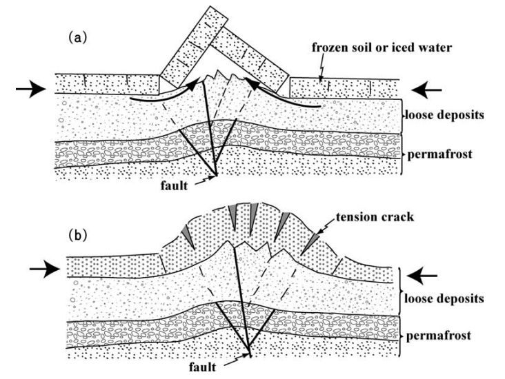
(b) bulge-type mole tracks. Both types of mole tracks were produced by
horizontal compression (indicated by short arrows). The angular-ridge
type mole track was produced by flexural slip folding and faulting of
the top rigid layer. The bulge-type mole track formed mainly by folding
and shortening of the unconsolidated to weakly consolidated alluvial
deposits. - Lin et al (2004)


Jarmaq Trench

Nemer and Meghraoui (2006) date Event Z to after 84-239 CE. They suggested the Safed Earthquake of 1837 CE as the most likely candidate.


Qiryat-Shemona Rockfalls

Kanari, M. (2008) examined rockfalls in Qiryat-Shemona which were attributed to earthquakes. Optically stimulated luminescence (OSL) dating was performed on soil samples beneath the fallen rocks. Kanari et al (2019) assigned Sample ID QS-4 to the 11th century CE Palestine Quakes which struck in ~1033 CE however the spread in ages for Sample ID QS-4 indicates that the 991 CE Damascus Quake is also a possibility.


Tell Saidiyeh and Ghor Kabed Trenches

Ferry et al (2011) detected 12 surface rupturing seismic events in 4 trenches (T1-T4) in Tell Saidiyeh and Ghor Kabed; 10 of which were prehistoric. The tightest chronology came from the Ghor Kabed trenches (T1 and T2) where Events Y and Z were constrained to between 560 and 1800 CE.

Note: Although Ferry et al (2011) combined archaeoseismic interpretations, their paleoseismic evidence, and entries from earthquake catalogs to produce earthquake dates and some overly optimistic probabilities, only the paleoseismic data is presented here. Ferry et al (2011)'s archaeoseismic data was researched and is treated separately.


Dead Sea - Seismite Types


Dead Sea - En Feshka

Kagan et. al. (2011) identified several seismites from around this time.

Depth (cm.) Thickness (cm.) Seismite Type Modeled Age (± 1σ) Modeled Age (± 2σ) Quake Assignment (Kagan) Quake Assignment (Williams)
74 1.5 4 1032 CE ± 19 1029 CE ± 43 11th century CE Palestine Quakes which struck in ~1033 CE not assigned
80 1.5 4 1009 CE ± 18 1004 CE ± 42 991 CE Damascus Quake not assigned
86 4 4 984 CE ± 21 976 CE ± 47 956 A.D., Local Source not assigned
104 6 1 912 CE ± 27 894 CE ± 61 873 A.D., Local Source not assigned


Dead Sea - En Gedi

Migowski et. al. (2004) assigned a 991 CE date to a 0.2 cm. thick linear wave (Type 1) seismite at a depth of 149.5 cm. (1.495 m).


Dead Sea - Nahal Ze 'elim

At site ZA-2, Kagan et. al. (2011) did not find any seismites whose time window encompassed 991 CE.


Araba - Introduction


Araba - Qasr Tilah

Haynes et al. (2006) dated Events II and III to between the 7th and 12th centuries CE.


Araba - Taybeh Trench

LeFevre et al. (2018) did not find any seismic events whose time window encompassed 991 CE.


Araba - Qatar Trench

Klinger et. al. (2015) dated Event Esupp1 to 925 CE ± 119 (806-1044 CE).


Notes

Ambraseys (2009)

AD 991 Apr 5 Damascus, Baalbeck

A damaging earthquake in Syria and Lebanon. It is said that in Damascus 1000 houses collapsed with loss of life, prompting the population to leave Damascus and camp in the desert. Damage extended over a large area, including the region of Baalbek, about 40 km away, as well as Dumayr, where ‘neither great or small escaped’. Details about other places are lacking

Aftershocks followed for almost a month, one being recorded for 2 May and another for 5 May, causing additional damage

Yahia and al-Makin have similar accounts of this earthquake and agree that the earthquake occurred on Muharram 17 a.H. 381, a Saturday night, namely 4–5 April 991 (al-Makin HS 254, HM 262/iii. 46). Al-Umari (f. 47r) gives only a.H. 381, but notes that the village which sank into the ground with great loss of life was called Duma, which is next to Damascus instead of near Baalbek as al-Antaki says, and gives Safar 17 a.H. 381, a Friday = Tuesday 5 May 991, for the final aftershock, whereas both editions of al-Makin give Safar 14 = 2 May (al-Makin HS. 254).

In al-Umari’s text the reading of Duma is not certain; it could be Dummar or most probably Dumayr, an important station on the trunk road to the north of Damascus.

Note

‘On Saturday 17 muharram at Damascus, a prodigious earthquake occurred, demolishing a thousand houses nearby and killing a great number of people. That night, the village of Ba’labak [or a village near Baalbek] collapsed. The earthquake ravaged Damascus and its satellite town of Ba’alabak. The inhabitants left their houses to take refuge in tents in the desert, and the earthquake went on without ceasing until Friday 17 safar.’ (alAntaki Tar. 173; al-Maqr. Ittiaz ii/273).

References

Ambraseys, N. N. (2009). Earthquakes in the Mediterranean and Middle East: a multidisciplinary study of seismicity up to 1900.

Guidoboni et al (1994)

(299) the night of 5 April 991 •Ba'albek, •Damascus

sources al-Antaki, Dhayl ta'rikh Ibn Batriq 173
literature Taher (1979)
catalogues Bonito (1691); Mallet (1853); Sieberg (1932 a); Ben-Menahem (1979); Poirier and Taher (1980)

al-Antaki — an Arab historian who lived shortly after the event narrated — records a series of tremors which caused the collapse of a great many houses in Damascus and forced the population to flee into the desert:

On the night of Saturday 17 muharram in the year 381 [of the Hegira = 5 April 991 AD] there was an earthquake at Damascus. More than 1000 houses collapsed, and a large number of people died. That same night, a village near Ba'albek was swallowed up by the earth. Other tremors occurred in Damascus and the surrounding area and Ba'albek. The people left their houses to take refuge in the desert, where they lodged in tents. The shocks went on repeatedly till Friday 17 safar [5 May] in the same year.
References

Guidoboni, E., et al. (1994). Catalogue of Ancient Earthquakes in the Mediterranean Area up to the 10th Century. Rome, Istituto nazionale di geofisica.

Taher (1996)

381/991: prodigious earthquake in Damascus, Muharram 17 (April 6 ); near a mining house are destroyed, causing the death of a large number of people; that night, the houses of Balabak collapsed. The inhabitants left their homes to seek refuge in the desert, under tents, and the tremors lasted until Friday Safar 17 (May 6)81.

Footnotes

81 Al-Antâqî, Târîkh, 173; al-Maqrîzî, itti`az, 2/273.

References

TAHER, M.A. (1996) "Les grandes zones sismiques du monde musul-mans a travers l'histoire. I. L'Orient musulman," Annales Islamologiques 30 (1996): 79-104. - open access

Taher (1979)

381 A.H./April 991 AD

On Saturday 17 Muharram in Damascus, a prodigious earthquake2 occurred, demolishing approximately a thousand houses and causing the death of a very large number of people. That night, the village of Baalbek collapsed. The earthquake devastated Damascus and its territorial constituency, Baalbek. The inhabitants left their homes to seek refuge in the desert, living under tents. The earthquake lasted without pause until Friday 17 çafar.

Footnotes

2 Al Antaki, Tarikh, 173; al Maqrizi, It'az, 2/273.

References

Taher, M.A. (1979): Corpus des texts arabes relatifs aux tremblements de terre et autres catastrophes naturelles, de la conquete arabe au XII H/XVIII JC, Ph.D. Thesis (Univ. Paris), 337 pp.

Paleoclimate - Droughts

References