
| Text (with hotlink) | Original Language | Religion | Date of Composition | Location Composed | Notes |
|---|---|---|---|---|---|
| Canonical Gospel Accounts - Matthew, Mark, Luke, and John | Greek | Christian | ~60 - ~110 CE | Various | In an allegorical passage, the Gospel of Matthew recounts an Earthquake in the moments after Jesus' death on the cross and again ~36 hours later just before the discovery of the empty tomb at Golgotha. None of the other canonical Gospel accounts mention these earthquakes. Matthew, Mark, and Luke describe a tearing of the curtain of the Second Temple in the moments after Jesus' death. |
| Gospel of the Hebrews | Hebrew, possibly Aramaic | Jewish Christian | Reputed to have been written between ~33 CE and ~40 CE. This Gospel has been lost but parts of it were quoted by later authors - primarily Jerome. Quotations supplied by Jerome came from a copy he accessed in 398 CE. | Jerusalem | The apocryphal Gospel of the Hebrews accessed by Jerome states that the lintel of the Second Temple broke in the moments after Jesus' death implying that this was caused by seismic activity. A lintel break due to seismic activity could explain the tearing of the curtain of the Second Temple reported in the canonical Gospels of Matthew, Mark, and Luke. Lintel damage is a frequent seismic effect as the lintel is one of the weakest parts of a structure. |
| Nature of the Canonical Gospel Accounts | The earliest possible date for the composition of the canonical Gospels appears to be after the 50s CE. | ||||
| Acts of the Apostles | Greek | Christian | ~62 - ~110 CE | Rome ? | The canonical Acts of the Apostles mentions a small seismic shock (possibly an aftershock) perhaps ~8 weeks after Jesus' death. The Acts of the Apostles is apparently beset with chronological inconsistencies. |
| The Doors of Hekal | The Babylonian Talmud, Josephus, and Tacitus relate that the Doors of Hekal of the Second Temple would spontaneously open due to supernatural forces. Spontaneous door opening could be due to prior seismic damage. The date for the spontaneous door opening is not well established. Perhaps it was in the 30s CE. Josephus also describes what could be another potential aftershock. | ||||
| The Chamber of Hewn Stones | Hebrew, Aramaic | The Babylonian Talmud describes how the Sanhedrin was exiled from the Chamber of Hewn Stones around ~30 CE which it attributes to the fact that they no longer had the authority to judge cases of fines and/or cases of capital punishment. Some have speculated that the reason for the exile is that the Chamber had been seismically damaged and made structurally unsound. | |||
| Temple Repair reported in The Jewish War by Josephus | Greek, possibly translated from an earlier version in Aramaic | Jewish | about 75 CE | Rome | Josephus relates that between 41 and 44 CE, timbers were brought to the Second Temple for the purposes of construction or possibly reconstruction. |
| Year of Jesus’ Death | The year of Jesus' death is not specified anywhere in the New Testament however chronological clues in the canonical Gospel Accounts along with an analysis using methods of Historical Astronomy indicates that 33 and 30 CE are the most likely years. The full time span for when Jesus died is constrained from 26 to 36 or 37 CE. | ||||
| Intensity of Shaking in Jerusalem | Second Temple damage suggests an Intensity of VI or VII. | ||||
| Conflation with an earthquake in Northern Turkey | Some ancient authors conflated the report of an earthquake in the moments after Jesus' death with the Solar Eclipse Quake of 29 CE in what is now northwestern Turkey. Due to the distances between northwestern Turkey and Jerusalem and other reasons, this is not possible. | ||||
| Gospel of Peter | Greek | Christian | Scholars are divided as to the exact date of the text. Ehrman and Pleše (2011) place it in the middle of the 2nd century CE. | The apocryphal Gospel of Peter recounts an Earthquake in the moments after Jesus' death as well as the tearing of the curtain of the Second Temple. | |
| Gospel of Nicodemus also known as The Acts of Pilate | Greek although questions of original language are debated | Christian | 4th or 5th century CE | The apocryphal Gospel of Nicodemus describes an earthquake and tearing of the curtain of the Second Temple in the moments before Jesus' death as well as a second earthquake associated with the discovery of the empty tomb. This Gospel also presents an interesting backstory which could provide a literary reason why an earthquake was included in some versions (e.g., Matthew) of the Passion narrative (see Biography drop down to the left for details). | |
| Literary Motif - An earthquake after the death of a a famous person | An earthquake is also reported after the deaths of Buddha, Mohammed, and Julius Caesar | ||||
| Text (with hotlink) | Original Language | Religion | Date of Composition | Location Composed | Notes |
| Location (with hotlink) | Status | Intensity | Notes | |||||||||
|---|---|---|---|---|---|---|---|---|---|---|---|---|
| Jerusalem - Introduction | n/a | n/a | n/a | |||||||||
| Jerusalem - Western Wall Tunnel | probable | ≥ 7 | Stratum 14 Earthquake - ~30 CE - Onn et. al. (2011) report earthquake damage to a pier under
Wilson's Arch adjacent to the
Western Wall Plaza by Temple Mount which they presumed to be due to an earthquake in 33 CE.
The date was constrained by the endpoints of the approximate completion of the
Herodian Temple rebuilding project and
the destruction of the Second Temple by then Roman General Titus
in 70 CE. Although the 70 CE endpoint is known with certainty, the end of the Herodian rebuilding project is not as certain but the bulk of the building was probably completed by
~27 CE. Regev et al (2020) performed radiocarbon dating and microarcheology on northern and southern piers under Wilson's Arch and reported radiocarbon dates of 20 BC - 20 CE for the northern pier and drainage channel and 30 - 60 CE for the southern pier (Regev et al, 2020: 9, 13). This would associate the northern pier with the original Herodian rebuilding project and the southern pier with a southerly expansion of the Bridge associated with Wilson's Arch initiated sometime after ~20-30 CE. Given the earthquake damage present under this bridge, this bridge expansion suggests it was also a repair. Repairs can be indicators of a reaction to seismic damage. Thus it seems probable but not certain that the Jerusalem Quake (31 CE ± 5) caused this seismic bridge damage. |
|||||||||
| Jerusalem - Jason’s Tomb | possible | ≥ 8 | Rahmani(1964:98-99) interpreted the collapse of “structured parts” of Jason’s Tomb in Jerusalem to be due to the 31 BCE earthquake. He noted the presence of Herodian remains (mainly oil lamps) on a plaster floor beneath earthquake debris. Since Herod conquered Jerusalem in 37 BCE and Rahmani (1964) dates sealing of the tomb to 30/31 CE, it was presumed that the responsible earthquake was the only one that Rahmani (1964) was aware of at that time – the Josephus Quake of 31 BCE. However, since then evidence for the Jerusalem Quake of 26-36 CE has come to light making the Jerusalem Quake another possible candidate for the collapse debris. If the Jerusalem Quake did cause archeoseismic damage to Jason’s Tomb, it may have added additional debris rather than being responsible for the original debris. | |||||||||
| Jerusalem - The Cracks of Calvary | indeterminate | In his catalog entry for the 33 CE Earthquake (i.e., the Jerusalem Quake), Ambraseys (2009) presents a discussion of the so-called cracks of Calvary at the Church of the Holy Sepulchre in Jerusalem. Although there are legends stating that these cracks were formed during the earthquake(s) of the Crucifixion, no-one to date has been able to either date the formation of the cracks or confirm or dis-affirm a seismic origin. So, while the discussion is interesting, it is not illuminating. | ||||||||||
| Heshbon | possible | ≥ 8 |
Mitchel (1980) identified a destruction layer in Stratum 14
which he attributed to an earthquake. Unfortunately, the destruction layer is not precisely dated. Using some assumptions,
Mitchel (1980) dated the
earthquake destruction to the 130 CE Eusebius Mystery Quake,
apparently unaware at the time that this earthquake account may be either
misdated as suggested by Russell (1985) or mislocated as
suggested by Ambraseys (2009).
Although Russell (1985) attributed the destruction layer
in Stratum 14 to the early 2nd century CE Incense Road Quake, a number of
earthquakes are possible candidates including the 31 BCE Josephus Quake. bedrock surface channels, presumably for directing run-off water into storage facilities, which now are totally disrupted, and in many cases rest ten to twenty degrees from the horizontal; by caves with carefully cut steps leading down into them whose entrances are fully or largely collapsed and no longer usable; by passages from caves which can still be entered into formerly communicating caves which no longer exist, or are so low-ceilinged or clogged with debris as to make their use highly unlikely — at least as they stand now.Mitchel (1980:73) also noticed that new buildings constructed in Stratum 13 were leveled over a jumble of broken-up bedrock. Mitchel (1980:95) reports that Areas B and D had the best evidence for the massive bedrock collapse - something he attributed to the "softer" strata in this area, more prone to karst features and thus easier to burrow into and develop underground dwelling structures. Mitchel (1980:96) reports discovery of a coin of Aretas IV (9 BC – 40 CE) in the fill of silo D.3:57 which he suggests was placed as part of reconstruction after the earthquake. Although Mitchel (1980:96) acknowledges that this suggests that the causitive earthquake was the 31 BCE Josephus Quake, Mitchel (1980:96) argued for a later earthquake based on the mistaken belief that the 31 BCE Josephus Quake had an epicenter in the Galilee. Paleoseismic evidence from the Dead Sea, however, indicates that the 31 BCE Josephus Quake had an epicenter in the vicinity of the Dead Sea relatively close to Tell Hesban. Mitchel (1980:96-98)'s argument follows: The filling of the silos, caves, and other broken—up bedrock installations at the end of the Early Roman period was apparently carried out nearly immediately after the earthquake occurred. This conclusion is based on the absence of evidence for extended exposure before filling (silt, water—laid deposits, etc.), which in fact suggests that maybe not even one winter's rain can be accounted for between the earthquake and the Stratum 13 filling operation. If this conclusion is correct, then the Aretas IV coin had to have been introduced into silo D.3:57 fill soon after the earthquake. which consequently could not have been earlier than 9 B.C.Mitchel (1980:100)'s 130 CE date for the causitive earthquake rests on the assumption that the "fills" were deposited soon after bedrock collapse. If one discards this assumption, numismatic evidence and ceramic evidence suggests that the "fill" was deposited over a longer period of time - perhaps even 200+ years - and the causitive earthquake was earlier. Unfortunately, it appears that the terminus ante quem for the bedrock collapse event is not well constrained. The terminus post quem appears to depend on the date for lower levels of Stratum 14 which seems to have been difficult to date precisely and underlying Stratum 15 which Mitchel (1980:21) characterized as chronologically difficult. |
|||||||||
| Structures in the Araba | n/a | n/a | Ben-Menahem (1979:259) and Ben-Menahem (1991:20198) report that three structures in the Araba were fortified to withstand earthquakes between the years 9 BCE and 50 CE. This could reflect indirect evidence of a recent earthquake; primarily due to a Nabatean pattern of quickly repairing structures after earthquakes during this prosperous period. He locates these structures in Petra, Tel el Haliefe, and Wadi Ramm. His references were Avi-Yonah (1975) Volumes III and IV and Gleuck (1943). | |||||||||
| Petra - Introduction | n/a | n/a | n/a | |||||||||
| Petra - Temple of the High Places | needs investigation |
Ben-Menahem (1979:259) and
Ben-Menahem (1991:20198) report that three structures in the Araba were fortified to withstand earthquakes between the years 9 BCE and 50 CE.
This could reflect indirect evidence of a recent earthquake; primarily due to a Nabatean pattern of quickly repairing structures after earthquakes during this prosperous period.
He locates these structures in Petra, Tel el Haliefe, and Wadi Ramm. His references were
Avi-Yonah (1975) Vol III and IV and
Gleuck (1943). Unfortunately, Ben-Menahem (1979:259) and Ben-Menahem (1991:20198) did not specify which structure at Petra was fortified. He may have been referring to the “Temple of the High Places” but absent specific information, it is not possible to assess this claim. Although there is potential archeoseismic evidence at the site (i.e. fractures in the steps and platform), the potential evidence is undated. |
||||||||||
| Aqaba - Introduction | n/a | n/a | n/a | |||||||||
| Aqaba - Tel el Haliefe | no evidence |
Ben-Menahem (1979:259) and
Ben-Menahem (1991:20198) report that three structures in the Araba were fortified to withstand earthquakes between the years 9 BCE and 50 CE.
This could reflect indirect evidence of a recent earthquake; primarily due to a Nabatean pattern of quickly repairing structures after earthquakes during this prosperous period.
He locates these structures in Petra, Tel el Haliefe, and Wadi Ramm. His references were
Avi-Yonah (1975) Vol III and IV and
Gleuck (1943). Tel el Haliefe site does not appear to contain any evidence for fortification of structures between 9 BCE and 50 CE. Pratico and DiVito (1993), Avi-Yonah (1975), and Glueck (1940) all state that the site appears to have been abandoned by 4th or 3rd century BCE at the latest. |
||||||||||
| Wadi Ramm - Er-Ram | possible | They key seismic discovery at the Temple to Allat is a
Thamudic inscription
discovered at the ruins on the site. The inscription may have been placed after the site was rebuilt due to earthquake damage. This may reflect be a pattern during this time
when the Nabateans rebuilt their temples (e.g., The High Places at Petra, Khirbet Tannur, and the Temple to Allat in Wadi Ramm) soon after earthquakes damaged them.
The inscription contains a fragment of a date: and this is written on the day/ . . . of Ab in the year 40 and . . . ,. 'Two alternatives were proposed for dating this inscription (Avi-Yonah, 1975)
|
||||||||||
| Herodium | possible | ≥ 8 | Mid-1st century CE Earthquake (?) - Netzer (1981:78) proposed that the damage observed in
the service building at Lower Herodium was probably due to an earthquake which occurred in the mid-first century A.D.This assessment was based on structural evidence such as the collapse of the barrel-vaulted ceiling in the storage hall—an event that destroyed dozens of storage jars—and the collapse of arches in Hall B41. However, Netzer (1981:27–28) cautioned that such a conclusion must be viewed with caution, as there is no definite evidence of such an earthquake from the other parts of the site. Numismatic finds, including coins of Agrippa I [r. 41-44 CE] and others discovered on the floors of the reconstructed building and in associated dumps, point to a date towards the middle of the first century A.D.(Netzer, 1981:27–28). Although Netzer (1981:27–28) tentatively linked the damage to the year 48 CE based on an entry in the earthquake catalog of Amiran et al. (1994), this specific date is considered unreliable. Supporting this general timeframe, Ahipaz et al. (2017:126) interpreted numismatic evidence from Herodium as indicating site abandonment during the 40s or 50s CE, which they speculated may have resulted from an earthquake. |
|||||||||
| Location (with hotlink) | Status | Intensity | Notes |
| Location (with hotlink) | Status | Intensity | Notes |
|---|---|---|---|
| Bet Zayda | unlikely | ≥ 7 | Although Wechsler at al. (2014) list the Jerusalem Quake as a candidate for causing surface rupture seen in event CH4-E6 (Modeled Age 392 BCE - 91 CE) in Bet Zayda, the estimated size and epicenter worked out by Williams (2004) suggests that it is an unlikely candidate and that their more favored candidate (the 31 BCE Josephus Quake) or the Northern Dead Fish and Soldiers Quake are more likely. |
| Dead Sea - Seismite Types | n/a | n/a | |
| Dead Sea - En Feshka | possible to probable | 7.9 - 8.8 | Kagan et. al. (2011) identified a 1 cm. thick Type 4 microbreccia seismite at a depth of 338 cm. which they dated to 63 CE ± 38 (1σ) and 61 CE ± 81 (2σ). They listed the 33 CE earthquake (i.e., the Jerusalem Quake) as the most likely candidate. |
| Dead Sea - En Gedi | possible | 8 - 9 |
Migowski et. al. (2004) identified a 0.2 cm. thick Type 1 seismite at a depth of 274 cm. (2.74 m) in the DSEn core taken at En Gedi and assigned it a date of 33 CE based on varve counting in the core.
Williams et. al. (2012) later worked on the same core that Migowski et. al. (2004) worked on and dated the same seismite to
26-36 CE using an identical varve counting technique but added an uncertainty estimate for the difficult to count varves. Although Migowski et. al. (2004) and Williams et. al. (2012) observed a very thin seismite (0.2 cm.) associated with the Jerusalem Quake in the En Gedi Core, subsequent field work by Williams in a gully (aka the En Gedi Trench) located ~40 meters from the core site has shown the Jerusalem Quake seismite to be substantially thicker (3 – 9 cm. with an average of 3-4 cm.) and Type 2. Thickening and thinning of seismites are frequently observed in outcrop and the thickness may be controlled by site effects, lithological changes, and subtle changes in topography (terracing) that cause the seismite layers to flow during earthquakes of longer duration. Migowski et. al. (2004) assigned a magnitude of 5.5 to the Jerusalem Quake seismite apparently based on the work of Ken-Tor et al. (2001a) which estimated a magnitude of 5.5 for the the seismite they assigned to the Jerusalem Quake (33 AD in their paper) in Nahal Ze'elim. This was based on an assumption by Ken-Tor et al. (2001a) that the Jerusalem Quake only produced a seismite locally at Nahal Ze 'elim (ZA1) and that an earthquake must be at least magnitude 5.5 to produce a seismite in the epicentral region. However, since seismites were observed at two locations (En Gedi and Nahal Ze 'elim), the magnitude had to be larger. Williams (2004) estimated the magnitude of the Jerusalem Quake to between 6.0 and 6.5 (~6.3) with an epicenter close the Jordanian town of Al Masraa. The methodology of Williams (2004) was to estimate local intensity based on seismite thickness, locate the causitive earthquake on known earthquake producing faults (in this case the Araba Fault), and use an attenuation relationship to estimate Magnitude. |
| Dead Sea - Nahal Ze 'elim | probable | 8.0 - 8.9 (All sites) |
Site ZA-2 - Site ZA-2 is more seaward than site ZA-1. At site ZA-2, Kagan et al (2011) dated a 4 cm. thick Type 4 seismite at a depth of 470 cm. to 52 CE ± 40 (1σ) and 56 CE ± 76 (2σ) and associated it with the 33 CE earthquake - i.e., the Jerusalem Quake. |
| Araba - Introduction | n/a | n/a | n/a |
| Araba - Taybeh Trench | possible | ≥ 7 | LeFevre et al. (2018) tentatively identified a poorly expressed seismic event (E5) in the Taybeh trench in the Araba which they modeled between 14 BCE and 205 CE. Although they identified the 31 BCE Josephus Quake as the most likely candidate, the ~31 CE Jerusalem Quake may be an even more likely candidate. LeFevre et al. (2018) noted that the poor expression of Event E5 (vertical cracks in the trench) meant that the cracks could have been caused by a later Event (E4) which they associated with the early second century CE Incense Road Earthquake. |
| Araba - Qatar Trench | possible to unlikely | ≥ 7 | The Jerusalem Quake, within Event E6's time window (251 CE ± 251), is a less likely candidate than other earthquake events such as the early second century CE Incense Road Earthquake or the southern Cyril Quake of 363 CE. |
| Location (with hotlink) | Status | Intensity | Notes |
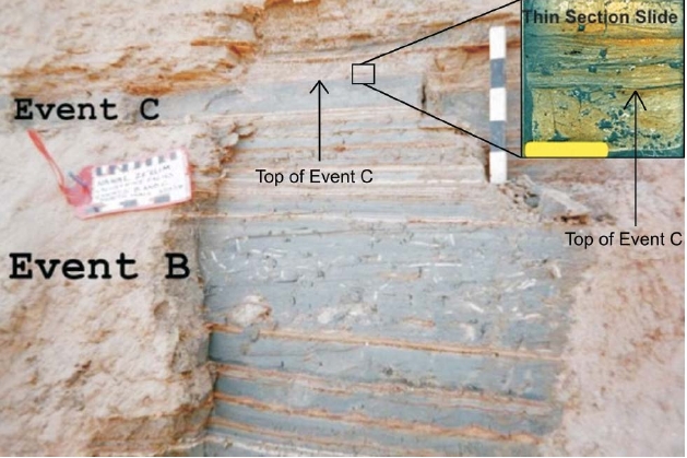 Figure 2
Photo taken by Jefferson B. Williams in May 2000
Figure 2
Photo taken by Jefferson B. Williams in May 2000
| Topic (with hotlink) | Notes |
|---|---|
| Seismic Amplification on Temple Mount | Temple Mount has a probable site effect due to fill. |
| Site Effect due to Fill | Site Effect due to fill is probable. |
| Topographic Effect | A topographic effect is possible at the Dome of the Rock. |
| Wave guide Effect | essentially the same as a topographic Effect |
| Slope Effect near the walls of Temple Mount | Structures on the edge of Temple Mount may be subject to a slope effect - particularly Al Aqsa Mosque. |
| Seismic threat to structures | Salamon et. al. (2010) report that the frequency range of seismic threat to structures lies in the 0.5 – 10 Hz. range. |
| Description of the Temple | Josephus described the Second Temple. |
| Caveat | A seismic model is required to take these speculations to the next level. |
| Topic (with hotlink) | Notes |
Uncompacted fill was laid down in the Tyropean Valley during Herodian times in order to create the
Temple Mount Platform. The fill was thick in many sections; perhaps as thick as 19 meters
Frydman (1997).
Uncompacted fill has a low shear wave velocity and seismic amplification is known to occur when a low shear wave velocity layer lies on
top of a higher velocity shear wave velocity layer(e.g. Dobry et al. 2000
and
Kawase, 2003); in this case Judea Group limestone. Below is a hypothetical cross-section of Temple
Mount showing the thickness of the fill.

While
Salamon et. al. (2010) exercise caution in declaring that there is a definitive site effect at Temple Mount, the thick low velocity fill,
the seismic history of structures on Temple Mount, the higher than expected intensities experienced during the 1927
Jericho Quake
(
Salamon et. al., 2010), and the Roof Collapse
 Seismic damage to Al Aqsa Mosque due to the 1927 Jericho Quake
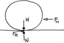
1 After the Sabbath, at dawn on the first day of the week, Mary Magdalene and the other Mary went to look at the tomb. 2 There was a violent earthquake, for an angel of the Lord came down from heaven and, going to the tomb, rolled back the stone and sat on it.A force balance calculation can be made to determine the minimum peak horizontal ground acceleration required to move the stone. At equilibrium conditions the disturbing force FH is balanced by the resisting force FR. When FH exceeds FR, the Rolling Stone will begin to move. A diagram and the calculation is shown below.
